Ice Age Atlantis and the Diaspora

Evolving research on Atlantis led the author to finally ask, “Which Atlantis did Plato describe in Critias and Timaeus? Ice Age Atlantis or Bronze Age Atlantis?” The author believes Atlantis fell at the beginning of the Holocene, during the onset of the Green Sahara, African Humid Period.

Introduction
The end of the Ice Age, during the transition from Pleistocene geological epoch to the Holocene, was a rare alignment of three orbital variations known as the Milankovitch Cycles. Changes in the Earth’s obliquity (tilt), precession (wobble), and eccentricity (orbit path) caused the sun to hit the ice sheets harder. The ice sheets melted into the ocean. Cold water oceanic inundation destabilized weather and climate. The Earth snapped upward from the weight shift of moving ice which caused seismic activity, earthquakes, and volcanic eruptions, and massive tsunamis. The Earth was a really wild place that attacked its human inhabitants who fled all directions, desperate to survive the aftermath.
This author invites the reader to consult previous articles to understand the amazing antediluvian world of Atlantis:
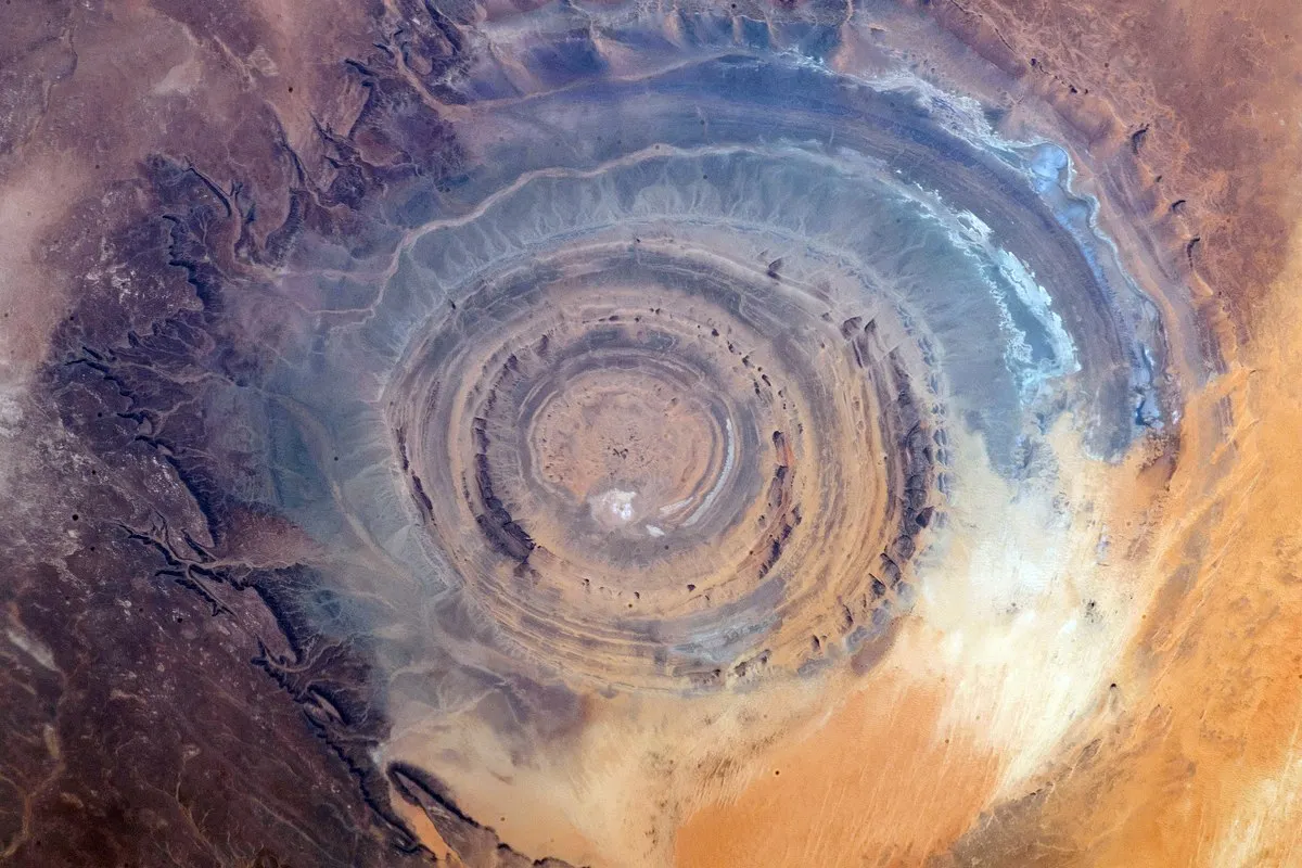
Yes, the Richat Structure was the Central City of Atlantis. [October 24, 2025] analyzes Plato’s narration on Atlantis and identifies the Richat Structure as the circular central city.
Coastal Sentinel for the Militaristic Atlantis Empire: Tidra Island [April 11, 2026] considers the inland location of the Richat Structure and discusses it’s connection by canal and river to the Arguin region of Mauritania and the Atlantic Ocean.
The Atlantis Confederation: Ten Kingdoms of the Ancient World [May 5, 2026] examines Atlas vocabulary that pre-dated Plato and converged in northwestern corner of Africa.
The author believes that (1) the central city of Atlantis existed at the Richat Structure. And (2) that the Western Mediterranean, the Maghreb, and surrounding coastal civilizations and islands of the Atlantic region formed the Atlantis empire. Also, (3) that the Egyptians, Greeks, and Romans converged their vocabulary and knowledge of Atlas in the northwestern corner of Africa. The author believes that (4) the description of the concentric circles and their match to the Richat Structure are too similar to ignore and that no other comparable formation has been located in this region. The author even believes (5) that the Egyptians informed both Solon and Herodotus of the correct time period, 9600 BC-9650 BC.
Ice Age Atlantis versus Bronze Age Atlantis
However, the evolving research on Atlantis has led the author to finally ask, “Which Atlantis did Plato describe? Ice Age Atlantis or Bronze Age Atlantis?”
Not if Atlantis. The answer to if is yes.
Not whether Atlantis. The answer to whether is also yes.
Not even wherever Atlantis. Wherever has also been answered.
The remaining question is whenever? When? When? Whenever was Atlantis?
If only Plato had made the journey to Egypt for clarification, as did Solon and Herodotus… Some say Plato did. But clearly, Plato did not.
And so, while the Egyptians accurately described to Solon and Herodotus a late Ice Age world that disappeared due to worldwide floods during the Holocene, Plato twisted the information he received from Solon (and maybe Hanno the Navigator?) by imposing descriptions of Bronze Age culture — swords, sandals, chariots, horses, Greek and Roman-style city-states — upon Ice Age culture. However, Plato did the world the favor of maintaining the original 9600 BC–9650 BC date.

If the Egyptians recorded then interpreted the accurate date to Solon and Herodotus… if Solon and Herodotus correctly calculated the dates and translated their meaning… if Plato reported the date by Solon faithfully… then Atlantis did reflect the late Ice Age/Pleistocene era and its transition to the Holocene and the African Humid Period.
While the later Bronze Age flood and resulting collapse of civilization heavily influenced Plato and the Greeks, the Egyptians of longer memory described Atlantis as the Holocene era ice melts that created worldwide chaos, catastrophe, and destruction. They described a time when the sky (heavy rain), the earth (seismic activity), and the water (tsunami) attacked humans and there was no hiding place.
So yes, Atlantis existed. Definitely. But not quite as described by Plato who, though detailed in the description of the Central City and certain other elements, de-coupled the rest of the choo choo and sent it off the tracks.
See also:
When Exactly Is Atlantis Believed to Have Existed?
Correct chronology of Atlantis . When did Atlantis appear and when did it disappear?
Egypt as the World’s Archive

As humanity recovered and rebuilt from the Holocene inundation at the end of the Ice Age, it wouldn’t be a surprise if terror of open water and the angry sea monsters lurking within it paralyzed the seafaring world to the point ocean crossings ceased. Global amnesia set in. Localized civilizations rose and fell. Libraries burned. Records disappeared, decomposed, or were looted. Wise elders with the memories passed away.
Modern humans lost their histories, identities, cultures, and information repositories to local wars, migrations, and smaller environmental collapses. The movie The Odyssey, written and directed by Christopher Nolan, expertly revealed how extreme acts of war and violence or, in this case, extreme acts of geological and climatic violence, could alter the cultures of the known world. Only one nation remembered the starting point — Ancient Egypt.
Egypt was surrounded by vast deserts which insulated it, for the most part, from the chaotic migrations and invasions that destroyed the cultures of other nations. Water did not assault Egypt. Water came. Water went. It rose and fell like clockwork, especially the Nile River. Because of this cultural stability, Egyptian priests maintained an unbroken chain of written records for thousands of years. In fact, this stability allowed the Egyptians to track two distinct worldwide flood events.
- The great Ice Age transition to Holocene of 9600 BC-9650 BC included a change in the Earth’s obliquity, precession, and eccentricity. Maybe the moon wobbled too affecting water waves on Earth. The effects physically changed the world and the people.
- The Bronze Age flood catastrophes around 1200 BC included social and political instability, wars, famine, the inability to address mega-droughts, the volcanic eruption of Thera, the resulting tsunamis, and the invasions of the displaced “Sea Peoples.”

When the Greek lawmaker Solon visited the Egyptian priests (Sonchis and Psenophis) at Sais, they told him: “You Greeks are always children… YOU REMEMBER ONLY ONE DELUGE ON THE EARTH…” Here, the priests referred to the Bronze Age flood, about 1157 BC, the floods that the Greeks remembered because it mostly affected their region of the world.
However, the priests continued their revelation to Solon, “…BUT THERE WERE MANY BEFORE IT.” And the Egyptians then told Solon of the Ice Age flood, of about 9600 BC–9650 BC. The Greeks, due to their own civil disruptions and internal warfare, could not maintain records of the Ice Age inundation that occurred so many thousands of years earlier.
Herodotus also visited the high priests of Egypt in Memphis, Heliopolis, and Thebes, who passed on similar knowledge to Herodotus as the priests in Sais did to Solon. They showed Herodotus 341 statues of high priests and explained the sheer length of Egyptian history. Herodotus calculated that generational lineage back to over 9,000 years ago from his time, which would be the Pleistocene to Holocene transition, circa 9600 BC–9650 BC. This period was a time of geological and climatic instability, human migration, even human genetic mutation. Once again, the Egyptians proved to the Greeks that Egyptian history lived while other histories died.
The Egyptians remembered what others forgot, including once-dry lands that submerged like Doggerland, Sunderland, and the Persian Gulf Oasis. They remembered the circular Richat Structure’s elevated water basin. They remembered the island pathways that led to the Americas, the “opposite continent.” Places that no longer existed in the time of Herodotus, Solon, Plato, all the way till today… the Egyptians remembered.
Plato’s Creative Imagination
Plato did exactly what the Egyptians warned against. He took recent memory of the Bronze Age flood, and imposed the culture of that time upon the late Ice Age flood. Plato reported Solon’s accurate date of 9600 BC-9650 BC, but populated that ancient world with the culture, technology, geopolitics, infrastructure, and warfare of the Bronze Age. He described “Atlantis” as having advanced trireme warships, bronze armor, and grand Greek-style palaces. He described a swords and sandals Gladiator, Game of Thrones, and Odyssey-style culture — Ice Age Atlantis with Bronze Age flair.
Perhaps Plato could not comprehend or accept the Richat Structure as a natural, massive ringed elevated basin being filled with mountain water run-off in the middle of what became a bone-dry, barren Sahara in his lifetime. He assumed it must have been an artificial city engineered by humans. So he described the Richat Structure overlaid by Greek, Roman, Egyptian, perhaps even Carthaginian infrastructure, architecture, and military culture during his discussion of the Atlantis central city in Timaeus and Critias.
To make the story a moral lesson for his fellow Greeks, Plato continued to expand the narrative. He claimed that Athens was the noble city that successfully fought off the Atlantean invasion. It has not yet been proven that Athens existed 9600 BC-9650 BC, at least not in the manner that Plato described. And, by the time of the Bronze Age, the desiccation of the Richat Structure region was well underway. For this reason, the wetland Atlantis central city that the Egyptians described in specific numerical detail could only have existed during the late Ice Age, not the Bronze Age.
What was Ice Age Atlantis?
During the last Ice Age, before the planetary reset around 9600 BC-9650 BC, highly-advanced, coastal, seafaring networks criss-crossed the globe. They created navigational technologies. They created maps. They told stories of their travels. They spread knowledge, culture, technology, and science. At that time, global sea levels were roughly 400 feet (120 meters) lower than they are today because the poles held most of the world’s water as ice.
Humanity of that time inhabited and occupied vast low-lying coastal networks that have since submerged and no longer exist. That once-dry land is now guarded by whales and sharks.
So, Atlantis was not an isolated Bronze Age island that sank into the Atlantic Ocean. Rather, Atlantis was a time. Atlantis flourished during the Ice Age and fell during the transition to Holocene when the glaciers melted and destabilized the climate, creating the “Green Sahara” of the African Humid Period. It was the antediluvian world that existed as a global network of distinct, geographic coastal and island kingdoms until it was overcome by tsunamis and catastrophic floods, including:

- The Richat Structure: Located in Northwest Africa, the Eye of the Sahara sits in a rocky, sandy, hot, dry barren desert baked by wind. But during the Ice Age, the famous concentric rings served as an elevated water basin that collected mountain run-off from rivers, tributaries, and mega-lakes. The Richat Structure’s naturally-formed, concentric rings of rock filled with navigable water. This water basin drained via a manmade canal that met the Tamanrasset River, then ran the water on to the Atlantic Ocean. The “Atlantis” central city was a natural phenomenon, modified by humans. Its unusual setting and location created a memorable, visually-stunning, defensible settlement for a powerful African kingdom. See also: “Yes, the Richat Structure was the Central City of Atlantis.”
- Doggerland: This massive, fertile landmass once connected Great Britain to mainland Europe. Populations flourished there until the rising seas and catastrophic tsunami made it go away. Lately, evidence has re-emerged of the civilization that once existed there.
- Sundaland: This giant, tropical subcontinent once connected Southeast Asia. During the Ice Age, the islands of Indonesia were part of the Asian mainland, covered by rich, fertile, volcanic soil. The ancient builders who dwelt there left buried megalith foundations, including those found at Gunung Padang in Java.
- The Persian Gulf Oasis: Sitting at the confluence of the Tigris and Euphrates Rivers, this fertile river valley is rumored to have been the location of the famed Garden of Eden, a human sanctuary before the Indian Ocean arrived to claim it.
- Tartessos [Tartarus, Tarshish]: This may have been another such coastal kingdom whose survivors fled into the Pyrenees Mountains.

At the end of the Ice Age, lands once above ground submerged. That’s it. That’s Ice Age Atlantis. Simple as that. Not magical. Not extra-terrestrial. Not inter-dimensional. Not a Stargate time portal. Long ago, it existed. Then it didn’t.
Trans-Atlantic Travel during Ice Age Atlantis

This antediluvian empire of advanced ancient kingdoms mastered global seafaring, including regular trans-Atlantic travel long before mainstream history deemed it possible. During the Ice Age, navigating the Atlantic was not the daunting experience it is today. Lower sea levels exposed vast underwater plateaus. The Atlantic Ocean held more contiguous land blocks for island-hopping from say, the expanded coastline of West African mainland to the larger-sized Canary Islands, the Azores, Madeira, the mid-Atlantic Ridge, Bermuda, all the way to the expanded coastlines of the Carolinas. With more land exposed, the journey could be achieved by canoe, a canoe like the West African Difuna canoe of 6556 BC. The shallow waters of the Bahamas Bank and the underwater stones of the Bimini Road also indicate the possibility of submerged maritime infrastructure.
On the eastern side of the Atlantic Ocean, the Egyptians possessed anomalies. Traces of tobacco and coca, plants entirely native to the Americas, have been found inside wrapped mummies of Egyptian pharaohs like Ramesses II. Because these plants were not native to the ancient Near East, their presence indicates the existence of a global trade network that also included products such as pineapple and cotton.
Furthermore, both the Mesoamericans and the Egyptians shared intense dedication towards building highly-precise, star-aligned stone pyramids. This architecture was likely not a coincidence. Far more likely, it was a shared cultural inheritance from a seafaring, trans-Atlantic empire of kingdoms that traded goods, mapped the stars, and communicated across the ocean before the worldwide floods tore the world and its people apart.

The ancient terrestrial globe calculated by Crates of Mallus (pictured above), the 1448 Bianco map (pictured below), and the Piri Reis map (pictured further below) indicate that more was known about the world in ancient times than previously believed.

Regarding the Piri Reis map, the Antarctic coastline (indicated by the purple arrow) may have been exposed to map-makers who surveyed the region prior to the change in Earth’s tilt. Or… it’s the southern tip of South America, curved to fit the map.

Goebekli Tepe and the Sphinx

Göbekli Tepe recalibrated the concept of human history with the discovery of a complicated, stone structure roughly dated to about 9600 BC in Turkey, created by hunters and gatherers prior to the advent of organized agriculture. Further, the true age of the Sphinx has been revealed by geologists such as Robert Schoch who observed the water erosion on the Sphinx’s surface and declared it’s creation was the African Humid Period. This would be approximately 10,500 BC to 9700 BC, the onset of the Holocene, when sufficient rain fell on that region to create the erosion.
Schoch’s timeline would place the Sphinx’s origin at the end of the last Ice Age, contemporaneous with the creation of sites like Göbekli Tepe, rather than during the Bronze Age reign of Pharaoh Khafre, 2500 BC. Archaeologists still struggle to follow the logic of the geologists.
Hominids of Atlantis
After time passed, descendants of the late Ice Age flood survivors referred to the rulers of these vanished worlds as “God-Kings.” This author speculated in a previous essay The Atlantis Confederation: Ten Kingdoms of the Ancient World that the people of Ice Age Atlantis were a special kind of hominid, similar to modern humans, but not quite like modern humans.
The author believes that the people of this period had special and specific types of knowledge or different types of knowledge that modern humans still have not quite grasped. Climatic disaster, harsh changes in the atmosphere and environment, changes in solar intensity, release of microbes and contaminants, malnutrition, massive migration, separation from communities, and the passing of generations of elders changed these people. The best metaphor would be how the environment changed gigantic megafauna to the ordinary-sized fauna equivalent that we see today.
Changed what, exactly? Speculation would be loss of extra-sensory perception, telepathy, telekinesis, remote viewing, complex memorization, advanced mathematics, advanced astronomy, and the technologies that interacted with those special skills. Perhaps they used certain regions of the brain or their senses in ways that humans no longer can.
Perhaps their skills were different. Their talents and capabilities were different. Their technology was different. These leaders could construct advanced mathematical and engineering calculations to solve structural load and geometry problems. They had special writing systems. Perhaps they had sharper instincts, hearing, and eyesight. Perhaps they understood the world in four dimensions. Perhaps they used sonic resonance and harmonics as physical sources of energy or long-distance communication. Maybe they had “weirding voices,” as in Dune. They simply had things that we do not have.
They may even have looked somewhat different. Likely, these ancient technicians were not magical entities or aliens. They were flesh-and-blood types of humans. And perhaps some were slightly different from modern man, just as the Neanderthal and Denisovan were slightly different from modern man. Perhaps these different types of humans were taller and stronger, with different physiological characteristics. Similar, but somehow, different. For instance, they may have had greater endurance due to richer diet or larger lung capacity. And then when the environment harshened, they became smaller like modern man. Just different.

Coming of age in the lush, elevated water basin of the Richat Structure during the heavily-oxygenated Pleistocene to Holocene, the Kiffians became mega-sized like the animals they hunted. The sky fell. The Kiffians scattered north, south, east, west and became extra-ordinary legends to ordinary humans. Those that fled east dwelt in Gobero while it was still wet. But when the water disappeared, they drifted further east to the Nile Valley and the Levant, becoming the famous… Nephilim? And did they direct the building or were they directed to build megalith structures and participate in war-mongering? The Kiffians had the strong-built torsos and legs of the Neanderthal. Again, men who average 6'8, and maybe some taller outliers at 7'5, would terrify ordinary men who averaged 5'5 with slender builds. They must have appeared monstrous, and maybe they became monstrous if there wasn’t sufficient food in the Nile Valley or the Levant to support their vast nutritional requirements. Perhaps the Kiffians would have attacked the smaller humans because there was insufficient game and marine life to hunt and fish. Perhaps this is the real reason they disappeared. Modern humans destroyed them in acts of self-preservation.

The Changes in the Atlantean World
When the ice sheets collapsed at the end of the late Ice Age as a result of the triple convergence of the Milankovitch Cycles, global sea levels rose and inundated then submerged the landscapes on a catastrophic scale within days, minutes, hours. Atlantis changed from the antediluvian world to the drowned world. Advanced infrastructure disappeared. Technology disappeared. Writing disappeared. Math, engineering, science disappeared. The “God-Kings,” disappeared or scattered wherever their boats or their feet allowed them to escape.
As described in previous essays, the survivors fled into high mountains and desert plateaus seeking safety and stability. Stripped of the specialized knowledge, perhaps even of food and basic resources, the next generation became illiterate survivors forced into a Stone-Age do-over with not much to start with. Their main preoccupation was day-to-day survival, not calculus. They had to adjust to harsh new environmental conditions in a world that had completely changed. Ice turned to water. Wetlands turned to desert. The oceans swallowed dry lands. Rivers disappeared. Islands disappeared. People disappeared. Oxygen depleted. The first generations of survivors remembered just enough to build architectural shrines to the old world. But as the elder members of these survivors passed away, the succeeding generations could not maintain the knowledge. The Kiffians (or God-Kings) weakened from malnutrition and oxygen deprivation. Eventually, history died and memory faded away.
Over generations, the descendants tried to remember. They looked at monuments and architecture still standing, perhaps some odd bits of scattered technology. Perhaps when they tried to search for the magical world of Atlantis that their elders spoke of, they found nothing but mud, sand, and rocks... or ocean. They knew their ancestors had mastered the art of interpreting physics, math, science, medicine, the Earth and stars, but they couldn’t effectively wield the technologies. They couldn’t understand the mural inscriptions or make the calculations. So they deified their ancestors. Those scientists, with their specialized knowledge, became magicians of myth and legend. And the Kiffians who were de-selected for survival by the new normal became the “men of renown.” One such antediluvian king of West Africa, “Atlas” even became an immortal god, the son of Poseidon, who held up the sky on both shoulders… the Atlas mountains.
The Edfu Texts and the Island of the Creators
In the previous essay on Atlantis, the author shared multiple myths and legends from many cultures about God-Kings locked away in subterranean and submarine places. The Egyptians, of course, have such stories, as well.
While the Egyptians shared parts of their history with foreign travelers such as Herodotus and Solon, they held back deeper secrets etched in the stone walls of their sacred temples, for instance, the Edfu Temple Texts (location noted on map of Nile River above). Carved into the sandstone walls of the Temple of Horus at Edfu, these texts describe a type of Primeval World — an era that existed long before the human Pharaohs. A time before this time.
According to their inscriptions, civilization began on a sacred, primordial island. This island was inhabited by an advanced group of beings known as the “Creator Gods” or Builders. The Edfu Texts state that a great catastrophe, often symbolized by a cosmic serpent, caused the ocean to rise and violently submerge the entire island. The home of the gods was permanently lost beneath the waves.
The Edfu Texts also record that the surviving Creator Gods fled the flooded island in ships. They arrived on the banks of the Nile, whose nomad population was just beginning to emerge from its own wild marshlands. These displaced survivors, the Ice Age Atlanteans, became the architects of Egypt. They used their lost homeland’s advanced geometry and astronomy as blueprints to lay the foundations for Egypt’s earliest temples. The Egyptians recorded that they were the inheritors of an advanced, seafaring civilization that had been drowned by an Ice Age deluge.
See also:
Decrypting the Temple of Edfu and the Edfu Texts
Atlantis Parallels: When Myths Echo Plato’s Lost Island
Tas Tepeler: The Twin Monuments of Recovery

But there were other survivors of the Holocene deluge who searched for environmental stability. Besides Egypt, where did they go? Searching the world, we could trace their path if we recognized physical and cultural evidence of rebuilding efforts in the immediate aftermath of the flood of 9600 BC. In southeastern Turkey, within a region that was once known as Tas Tepeler, the twin sites of Göbekli Tepe and Karahan Tepe (described as the world’s earliest known human village), dated from 10,000 to 9500 BC, rose about this time period.
As with the true age of the Sphinx, mainstream archaeology has struggled to explain these locations. They feature massive, multi-ton T-shaped stone pillars carved with exquisite, high-relief artwork of animals, star constellations, human anatomy, and complex geometric symbols. According to the traditional timeline, the world in 9600 BC was populated only by primitive hunter-gatherers who had not yet invented agriculture, pottery, or metal tools. To the archaeologists, it is historically impossible for people wandering around looking for roots and berries and chasing deer to all of a sudden organize and manage thousands of workers, quarry massive blocks of limestone, transport them, align them precisely with the stars, then inscribe them with complex pictographs. So it is claimed…
Unless, like the Maya and the Olmec and the Egyptians, the hunter-gatherers had a boost with the introduction of leadership from an older, more advanced civilization…
The twin sites make perfect sense if viewed as monuments to recovery built by the survivors of the Ice Age meltdown.
Following the global flood, the remaining highly-skilled elites — the “God-Kings” and “Builders” mentioned in ancient texts — became leaders of the nomadic populations of the Fertile Crescent. Göbekli Tepe and Karahan Tepe were constructed not just as temples, but as cultural arks of record. Their massive stone enclosures were perhaps built to preserve and transmit long-lost data.

Possibly, the carvings on the pillars record astronomical alignments to warn future generations about the Milankovitch cycle convergence which destroyed the previous world. The Çatalhöyük (circa 7100 BC) settlement, also in Turkey, may have also housed a remnant Atlantis population, clustered tightly-together with rooftop pathways against violent environmental assault.
In light of these theories, the sudden appearance of domesticated agriculture at this time and location doesn’t seem coincidental.
The Fractured Diaspora and the Genetic Shift
Get Lee McQueen [BA, Poli Sci & Master of Lib Science]’s stories in your inbox
Join Medium for free to get updates from this writer.
As the centuries passed from the initial recovery at Turkey’s Tas Tepeler, the unified knowledge of the antediluvian world fragmented. Once connected by ancient seafaring, survivors scattered across different continents. The waters rose and cut them off from return. And perhaps paranoia of the deep angry ocean encouraged them to adapt to their new local environments. Without the centralized global network of the “Atlantis” Empire, local Stone Age cultures advanced in place, guided by the remnant Atlantean survivors.
This geographic splintering did not just fracture human culture; it may have forced a physical change in certain human biology, triggering the genetic emergence of pale skin, starting in the Near East, the Anatolian, or Tas Tepeler region. Before the 9600 BC-9650 BC deluge, the hunter-gatherers of the northern coastal plains (such as Doggerland) possessed a uniform phenotype: blue or green eyes paired with very dark skin, sustained by a high-seafood marine diet rich in natural vitamin D.

Shavit, Joseph. “Most Europeans had dark skin until 3,000 years ago, study finds.” Brighter Side News. https://www.thebrighterside.news/post/most-europeans-had-dark-skin-until-3000-years-ago-study-finds/ Accessed 08/05/2026.
However, when the 400-foot sea-level rise permanently drowned these coastal regions, northern branches of the Atlantis empire fled into the high altitude, cloudy, dark mountainous interiors of Europe and had less requirement for melanin because of the weaker sunlight. Because the melanin was not required, those who lost melanin did not suffer. Those with paler skin were still able to absorb enough UV to protect folate for reproduction. In fact, the individuals who carried specific gene variants, such as SLC24A5, which halted dark melanin production possessed the advantage in this region. Their pale skin readily absorbed the weak northern sunlight and synthesized the vitamin D. This genetic advantage provided a balance between vitamin D and folate (vitamin B9) which saved their bones from rickets and protected their reproduction.
The Anatolians of the Near East also developed these post-flood adaptations. However, their agricultural-based, high-grain diet added permanence to skin lightening because they were deprived of the marine vitamin D. The pale Near East population migrated west and introduced agriculture, grain, and the added genetic adaptation to other European populations. Albinism of certain numbers of Africans drove this vulnerable population northward to seek relief from harsh desert sun and UV radiation in the mountainous regions of Eurasia. In addition, Near East inter-breeding with the UV-sensitive, pale-skinned, red-haired Neanderthal populations who were numerous in Turkey, Ukraine, and Russia firmly cemented the pale skin mutation. Various factors led to the dominance of pale, light, and white skin in the northern extremeties of the world.
However, not until the Bronze Age (about 3,000 to 5,000 years ago) did light skin alleles reach high frequency across most of the Near East and Europe. Genetic data suggests that while SLC24A5 spread early with farmers, the SLC45A2 variant remained at low levels in the Near East and Europe until roughly 5,800 years ago, and then with (1) weaker sunlight, (2) organized agriculture and changes in diet, (3) concentration of albino and Neanderthal genetics, light skin increased and became common across Europe and Asia.
Meanwhile, the Atlantis diaspora that remained in or migrated to equatorial, high-sun zones — such as the Olmec and Maya in Central America, the Tamil in Southern Asia, or the Egyptians and Berbers and Bantus in Africa — did not face threat from the sun. Because these southern populations possessed ample sunlight to synthesize vitamin D, their bodies never dropped their pigment. They did not mutate. Their dark skin remained a natural sunscreen that shielded folate and their reproductive DNA. Neither did they inter-breed with the Neanderthal, since the Neanderthal were UV-sensitive and could not reproduce in these high-UV regions.
During the time of Ice Age Atlantis, the Atlanteans were dark-skinned. And on the African continent, they were almost certainly Black, taller, stronger, with a special set of skills, perhaps, reminiscent of the Kiffians. Modern genetic sequencing of ancient DNA confirms that before the 9600 BC deluge, the entire global population was uniformly black and dark-skinned. Dark skin was the default ancient phenotype of the world.
For instance, though ancient Carthage and Carthaginians are often vaguely described in modern texts as “Phoenician” and “Punic” and “Mediterranean” and “Levantine,” their location is on the continent of Africa. Though colonized by invaders, the indigenous population was dark-skinned, negroid, Black, African. Not European and not Asian. As was ancient Egypt dark-skinned, negroid, Black, African… scientifically verified by Chiek Anta Diop at the UN. As is today’s South Africa, though colonized by White Europeans and Asians, still majority dark-skinned, negroid, Black, African. Scholarly consensus is not evidence when scholars consent to misinform about evidence.
The Black Americans

“Mainstream archaeology” remains committed to the Beringia model of American settlement. They claim that the earliest Americans walked on foot from Siberia into Alaska. However, just like the proper age of the Sphinx, geological reality also refutes this questionable archaeological claim. During the peak of the Ice Age, North America was completely blockaded by the impassable, miles-high walls of the Laurentide and Cordilleran ice sheets. There was no entry into America at Beringia.
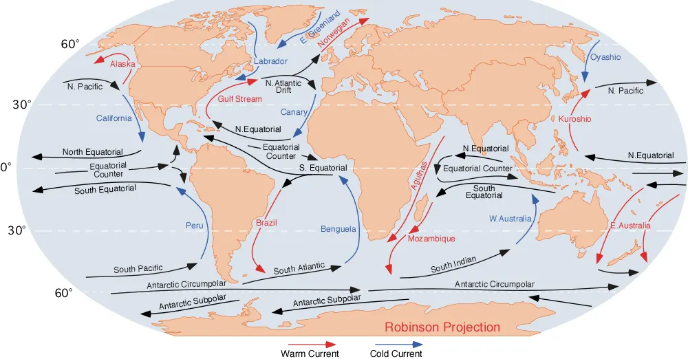
On the other hand, Africa was lush. Southern and equatorial Atlantic Ocean currents remained open and fluid as unobstructed maritime superhighways. Driven by highly advanced navigation skills, the seafaring kingdoms of “Atlantis,” had already utilized the natural conveyor belt of the Canary and North and South Equatorial currents to bridge the ocean.

The absolute first inhabitants of the Americas did not arrive from the frozen north. They arrived from across the Atlantic Ocean, possibly as Atlantis refugees, if not already part of the antediluvian global seafaring culture before the floods. Possibly, they arrived from Melanesia via the Pacific Ocean on the Equatorial Counter Current. But when they entered the Americas, they were dark-skinned. They were dark brown and Black. They carried humanity’s original, high-melanin physical baseline into the American continent millennia before the northern ice sheets melted. And this makes the case for pre-Columbian and pre-Asiatic Siberian Black indigeneity in the Americas.

In the the southeastern US, the Caribbean, Mexico, Central and South America, this isolation preserved the original antediluvian baseline of dark skin and negroid features. Safe on high-sun equatorial ground, the indigenous populations of the Americas had no biological need to mutate to pale skin. They retained their high melanin as a natural sunscreen designed to protect their folate and reproductive DNA.
Dark and black-skinned populations already occupied the Americas and left remains such as: Peñon Woman III, Mexico City, (12,700 years ago); the Spirit Cave Mummy, Nevada (9,400 years ago); and Kennewick Man, Washington State (9,000 years ago). They had long and narrow skulls (dolichocephalic) as well as facial phenotypes and proportions that matched ancient African and Australian populations.

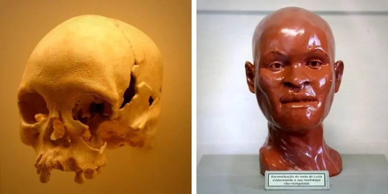
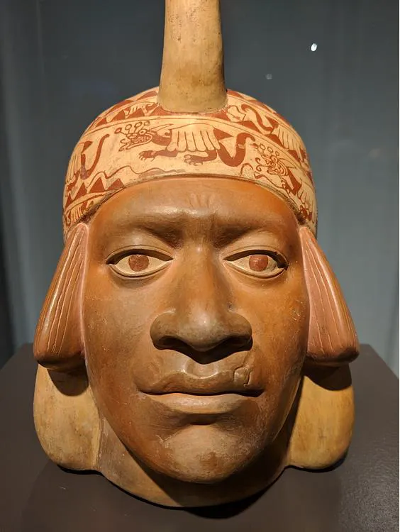
This also explains the “negroid” features carved into the monolithic Olmec Colossal Heads, the Wuthenau figurines, the Bonampak murals, and the dark-skinned populations repeatedly documented by conquistadors, explorers, and missionaries of America. The original, dark-skinned indigenous population of the Americas maintained the ancestral physical blueprint of humanity. They were the original people who traveled to the Americas during the seafaring time of “Atlantis.” And some fled to the Americas after the Holocene floods, which would explain the 11,500-year-old presence of “Luzia” in Brazil and the 12,000-year-old presence of “Naia” in the Yucatan.
If a number of the uniquely-formed Kiffians also fled across the Atlantic to the Americas, then that would explain the appearance of the large-sized “Patagonians” of South America and the efforts of later populations to mimic the Kiffian flat and elongated head shapes. It would explain Chief Tuskaloosa the large-sized “Black Warrior” of the Missippian Culture in Alabama who fought against Hernan de Soto.
There in the Americas, the Black indigenous Atlantis Diaspora and their descendants remained until encountered by the Asiatic Siberians who migrated from the Near East into Siberia, and then were finally allowed passage into the Americas once the Laurentide ice sheets retreated.

Another branch of the Atlantis diaspora established itself in the Supe Valley of Peru at Caral (Norte Chico) around 3000 BC. While Egypt built its Old Kingdom dynasties, people at Caral constructed massive, flat-topped stone pyramids. They relied on quipus (knotted strings that colonizing forces destroyed as “witchcraft”) to record their data. Caral represents another highly-specialized branch of the post-flood diaspora that retained the macro-engineering blueprints for building grand pyramids.
Later, the Olmec “mother culture” of Mesoamerica appeared in Mexico around 1600 BC with highly-advanced engineering skills. The later Maya developed highly-complex mathematical and astronomical calendar systems that tracked cosmic cycles over tens of thousands of years. Data this complex had a head start with key inputs from an older, longer-lived civilization.

The Missing “Rosetta Stone”
History remains one of the greatest mysteries to those who did not live through it. Even now, linguists struggle to translate the symbols found on ancient megaliths.
Knowledge of the sophisticated antediluvian network called “Atlantis” (documented by the Egyptian priests, transmitted to Solon and Herodotus, reimagined by Plato) remains mostly inaccessible because of the struggle to decipher the records. A dual-language bridge is required, something like the Rosetta Stone that decoded Egyptian hieroglyphs.
And where might such a dual-language bridge be? Think like a flood survivor. Somewhere… etched in stone. Somewhere high. Somewhere dry. Or buried within the confines of the numerous pyramid constructions.
If such a bilingual text survived the lateIce Age Atlantis planetary reset, it likely would remain in the places that survivors of a catastrophic flood would have stored it for long-term safe-keeping. Some place of extremely high altitude, stable environment, or unbroken cultural preservation.
Several locations emerge as a likely storage vault, such as:
The Vaults of Egypt (Giza or Sais): As the designated archive of the Mediterranean, the most promising location is within the unexcavated chambers beneath the Nile plateau. It would have been safe from Romans, Greeks, Turks, Persians, and Islamic conquests. Because the Egyptian priests knew their culture was under threat, they did not expose their deepest secrets. The Edfu Texts specifically state that sacred records were kept in hidden, subterranean chambers. And because Egypt’s desert sand acts as a natural preserver, any dual-language lexicon hidden under Giza or Sais may still remain hidden from looters and colonizers.
The Mounds of Tas Tepeler (Turkey): With less than 10% of Göbekli Tepe and Karahan Tepe excavated, the mountain complexes offered a pristine sanctuary for hidden knowledge. Turkey has been the crossroads for constant warfare and colonization, trampled by the Hittites, Greeks, Romans, Byzantines, and Ottoman Turks. Fortunately, the inhabitants preserved their ancient secrets when they buried them.
The High Andes (Tiahuanaco, Bolivia): At 13,000 feet above sea level, this megalithic complex escaped the 400-foot sea-level rise. The colonizing Spaniards did burn most quipus at the orders of the Catholic Church, because they branded what they didn’t understand as idolatrous. However, if the language bridge was etched into indestructible, multi-ton megalithic blocks of high-altitude fortresses like Puma Punku or Tiahuanaco, then it may have survived.
The Pyrenees Cave Vaults (France/Spain Border): When the 400-foot sea-level rise drowned Doggerland and the Atlantic coastlines, those refugees may have fled into the limestone cavern networks of the Pyrenees.
Himalayan Monasteries: Deep within the Himalayas, isolated archivists have historically maintained documents written in ancient, dead languages without interference from outside civilizations.
The Grand Canyon: Cavern networks provided high, dry ground that escaped marine flooding. Reports are that certain sections shelter early human artifacts and records.
Runners-up: The Library of Alexandria (and then the Vatican if the Romans stole the Alexandria Library’s records before burning it), Timbuktu of Mali, the Gobi Desert, the South Pole… and… the Slide Complex off the coast of Mauritania, where the floods deposited rubble from the Atlantis Central City or… Ouadane if the scattered remnants and rubble were used to build within 18 miles of the Richat Structure.
What could the world learn from Ice Age Atlantis?
The Richat Structure, Adrar, El Beyyed landscape contains numerous funerary monuments. The broader area of central Mauritania contains at least 12,000 funerary monuments. Many remain undated and unexcavated. This author predicts evidence of Kiffian culture will be revealed in this region and many questions about this mythical, legendary, fantastical time will be answered.
Excavation of pre-deluge data stored before the 9600 BC reset would also reveal forgotten physics; acoustics; engineering; energy; kinetic, structural, and mechanical principles used to manipulate multi-ton megaliths. This knowledge would change modern construction and infrastructure systems.
The flood survivors focused with intent on tracking the clockwork mechanics of celestial events. They understood that Earth would be subjected to cyclical cataclysms driven by solar flashes, orbital variations, and comet debris streams, all of which could trigger planetary resets like Holocene transition. They understood the triple convergence of the Milankovitch Cycles and what that would mean for mankind’s survival. Acquisition of this data would prevent collective amnesia until the next skyfall. Humanity would have the foresight to protect and preserve global infrastructure and records and themselves before the next reset.
Conclusion: Reviewing the Myths
There was a time before this time. That time was filled with amazing animals, chimerical hominids, stunning landscapes. But that time was not Middle Earth or Narnia or Camelot.
Plato did not invent Atlantis out of thin air. He imperfectly transmitted the story of a late Ice Age catastrophe that had been preserved by the world’s greatest archivists— Ancient Egypt.
Atlantis was a vast coastal network of Ice Age kingdoms, anchored by the unique ringed waters of the Richat Structure. This centralized position in northwest Africa connected the world’s trade, transportation, and geopolitics north, south, east, and west. Rising seas of the global reset sent this network back to the Stone Age culture. The Pleistocene to Holocene geological changes transformed the Green Sahara during this African Humid Period. The chaos also transformed people through migrations, deselections, and genetic mutations.
The coastal network rose again for the more-advanced empires of the Bronze Age. And then the clock reset again. And now, newer empires have risen worldwide. And the clock is once again ticking for the next reset.
Based upon past evidence, it is almost certain that the pyramid inscriptions will outlast our USBs and DVDs and “clouds” and streaming services and text messages and emails.
Fortunately, as the Egyptians noted, while most of our cultures suffer collective amnesia, the stones and the temple walls and the megaliths remember.
Epilogue: The Resilience of Stone
While centuries of brutal colonization and religious conquests silenced the living memory of the antediluvian world and its people, the true builders left behind fail safes that the invaders didn’t completely destroy.
They carved their legacies directly into the very stones of the earth.
The first Atlantis fell at the end of the Ice Age.
The second Atlantis fell at the end of the Bronze Age.
The third Atlantis… well… I guess, we’ll see…
See also:
Black Indigenous in the Pre-Columbian Americas: THE BLACK AMERICANS, Part 1
Pre-Columbian “Negroid” Remains in the Americas: THE BLACK AMERICANS, Part 2
Black Indigenous Aspects of Pre-Columbian Art and Artifacts: THE BLACK AMERICANS, Part 3
Pre-Columbian Black Indigenous Legacy, Writing, Botany: THE BLACK AMERICANS, Part 4
Ethnogenesis of the Black Indigenous: THE BLACK AMERICANS, Part 5
MODERN REFERENCES
Boyle, Alan. “Naia Reborn: See the Surprising Face of a First American.” NBC News, January 8, 2015. NBC News.
Díaz-Montexano, Georgeos. “Correct Chronology of Atlantis: When Did Atlantis Appear and When Did It Disappear?” Medium, July 6, 2025. medium.com
Dhwty. “Decrypting the Temple of Edfu and the Edfu Texts.” Ancient Origins, July 30, 2020. Ancient Origins
Herbert, Frank. Dune. New York: Chilton Books, 1965. Context: Invoked as a literary analogy (“weirding voices”) to describe the potential use of sonic resonance and harmonics as ancient physical energy or communication systems.
Howells, Caleb. “When Exactly Is Atlantis Believed to Have Existed?” GreekReporter.com, November 2, 2025. GreekReporter.com
López, Alejandro I. “The Tragic Story Behind the Oldest Human Skeleton in the American Continent.” Cultura Colectiva, March 30, 2019. Cultura Colectiva
Irwanto, Dhani. “Atlantis Parallels: When Myths Echo Plato’s Lost Island.” Medium, October 2, 2025. Medium
McQueen, Lee. “Coastal Sentinel for the Militaristic Atlantis Empire: Tidra Island.” Medium, April 11, 2026. medium.com.
McQueen, Lee. “The Atlantis Confederation: Ten Kingdoms of the Ancient World.” Medium, May 5, 2026. medium.com.
McQueen, Lee. “Yes, the Richat Structure was the Central City of Atlantis.” Medium, October 24, 2025. medium.com.
Nolan, Christopher, dir. The Odyssey. Hollywood, CA: Warner Bros. Pictures / Paramount Pictures, [n.d.]. Film. Context: Used as a cinematic metaphor to explain how sudden, extreme structural violence (warfare or climate catastrophe) causes massive historical amnesia across a fragmented diaspora.
Schoch, Robert M. Voices of the Rocks: A Scientist Looks at Catastrophes and Ancient Civilizations. New York: Harmony Books, 1999. Context: Referenced for his geological study of precipitation-induced water erosion on the Great Sphinx enclave, establishing a construction timeline during the African Humid Period (circa 10,500–9700 BC).
Shavit, Joseph. “Most Europeans had dark skin until 3,000 years ago, study finds.” The Brighter Side of News, November 27, 2025. thebrighterside.news. Context: Cited by the author to support the claim that dark skin and dark eyes were the default ancient human phenotype across Europe and the northern coastal plains (example, Doggerland) until a post-flood agricultural shift and geographic fragmentation favored genetic mutations like the SLC24A5 allele.
Starr, Michelle. “DNA Analysis Reveals Britain’s Oldest Known Modern Man Had Dark Skin.” ScienceAlert, February 8, 2018. sciencealert.com.
Wuthenau, Alexander von. Unexpected Faces in Ancient America: The Historical Testimony of Pre-Columbian Artists. New York: Crown Publishers, 1975. Context: Referenced via the “Wuthenau figurines” to argue for pre-Columbian and pre-Asiatic Siberian phenotypic diversity, specifically dark-skinned populations with distinct features in ancient Mesoamerica.
CLASSICAL REFERENCES
Herodotus. The Histories. Translated by Aubrey de Sélincourt. Revised by John Marincola. London: Penguin Books, 2003. Originally composed circa 440 BC. Context: Details Herodotus’s gathering of historical records from Egyptian high priests tracking a 9,000-year generational lineage back to the Pleistocene-Holocene transition.
Plato. Timaeus and Critias. Translated by Desmond Lee. London: Penguin Books, 2008. Originally composed circa 360 BC. Context: The primary foundational texts analyzed by the author. Plato is noted for blending Solon’s Ice Age chronological dates (9600–9650 BC) with heavily stylized Bronze Age structural flourishes (triremes, bronze armor, and city-state geopolitics).
Solon. Fragments and Historical Accounts of the Egyptian Voyage (Sais). In Plutarch, Life of Solon. Translated by Bernadotte Perrin. Cambridge, MA: Harvard University Press, 1914. Solon’s Egyptian voyage traditionally dated circa 590 BC; Plutarch’s Life of Solon originally composed circa 100 AD. Context: Details Solon’s direct discourse with Egyptian priests Sonchis and Psenophis at Sais regarding multiple global deluges pre-dating Greek historical memory.
Soto, Hernando de. The De Soto Chronicles: The Expedition of Hernando de Soto to North America in 1539–1543. Edited by Lawrence A. Clayton, Vernon James Knight Jr., and Edward C. Moore. Tuscaloosa: University of Alabama Press, 1993. Context: Referenced implicitly regarding the historical encounters between Spanish conquistadors and large-statured Mississippian Culture leaders, specifically Chief Tuskaloosa (the “Black Warrior”) in Alabama.
CARTOGRAPHY
Bianco, Andrea. The Bianco World Map. Venice, 1448. Manuscript map. Context: Cited to show that pre-modern maritime cartographers preserved an empirical layout of global landmasses prior to the modern Age of Discovery.
Crates of Mallus. The Terrestrial Globe of Crates. Map model, ca. 150 BC. Context: Referenced as an ancient representation of global geography demonstrating early mapping of the terrestrial sphere.
“A Map Highlighting the Stone Mounds Area and Nearby Settlements.” Türkiye Today, January 30, 2025. Türkiye Today.
T. y. kriptonita. “Map of Tartessos with Phoenician and Greek Colonies.” World History Encyclopedia, April 26, 2012. World History Encyclopedia.
U.S. Geological Survey. “Mid-Atlantic Ridge.” Wikimedia Commons, October 21, 2003. Wikimedia Commons
Encyclopaedia Britannica. “Nile River Valley in Ancient Egypt.” Encyclopaedia Britannica, n.d. Encyclopaedia Britannica
Piri Reis. The Piri Reis Map. Istanbul, 1513. Topkapı Palace Library, MS Revan 1633. Context: Analyzed for its accurate depiction of the Atlantic basin and its controversial rendering of either an ice-free Antarctic coastline or a curved South American landmass.
MATERIAL ARTIFACTS
Bonampak Murals. Chiapas, Mexico. Classic Maya civilization, circa 790 AD. Paintings. Context: Cited alongside the Olmec Colossal Heads as physical and artistic evidence documenting dark-skinned populations in the ancient Americas.
Caral-Chupacigarro Quipus. Supe Valley, Peru. Norte Chico civilization, circa 3000 BC. Knotted string mnemonic system. Context: Noted as an advanced macroeconomic recording technology utilized by a specialized branch of the post-flood diaspora in Peru, later targeted and destroyed by colonizing forces.
The Edfu Temple Texts. Sandstone inscriptions. Temple of Horus, Edfu, Egypt. Context: Hieroglyphic inscriptions describing a primeval era where “Creator Gods” or Builders fled a submerged primordial island following a cosmic catastrophe, arriving in the Nile Valley to serve as the architects of Egypt’s earliest star-aligned temples.
“Luzia.” Paleoindian skeletal remains. Lapa Vermelha, Lagoa Santa, Brazil. Dated circa 11,500 BC. Context: Cited alongside “Naia” as physical skeletal evidence of human presence in South America immediately following the Holocene floods, used to support theories of early trans-Atlantic maritime migration.
“Naia.” Paleoindian skeletal remains. Hoyo Negro, Quintana Roo, Mexico. Dated circ. 12,000–13,000 BC. Context: Cited alongside “Luzia” to demonstrate a late-Pleistocene/early-Holocene human presence in the Yucatan peninsula following the planetary reset.
Olmec Colossal Heads. San Lorenzo, La Venta, and Tres Zapotes, Mexico. Preclassic Mesoamerica, circa 1200–400 BC. Basalt sculptures. Context: Cited as monumental physical evidence displaying specific anatomical features that the author attributes to an original, high-melanin antediluvian baseline population surviving the Atlantis diaspora.